
How a Ritchie County Property Search Starts
Start with one solid clue. The Ritchie County Assessor Property Record Search accepts a Parcel Address, Owner Name, Account Number, District, Map/Parcel, Property Type, Legal Description, or Deed Book/Page. That freedom is useful, but restraint works better. The form itself notes that any combination of criteria may be entered. Fill in one or two fields only. An old road name or a slightly different name spelling can then be worked around without hiding the match you actually need.
- Enter the situs address in Parcel Address, or enter an owner as LAST NAME FIRST NAME with no comma.
- Open the likely parcel and write down account, district, map/parcel, legal description, situs and mailing addresses, and deed book/page.
- Use the name and reference in the County Clerk Document Inquiry to locate the deed or other instrument.
- Carry account or map/parcel to the sheriff tax inquiry and to the WV Property Assessment Viewer.
- If a current transfer, boundary, or tax balance matters, request the underlying record from the custodian.
This order keeps the Ritchie County property search anchored to the land record. Searching the assessor portal is free. Its result, though, does not show every recorded clause. The clerk's party index answers that gap, and it can be searched by grantor, grantee, creditor, debtor, and document categories. A map click adds helpful context. The deed and survey still govern the legal details.
The Ritchie County Assessor Search Fields
Owner Name carries the clearest formatting rule. Type LAST NAME FIRST NAME with no commas. When a full name returns nothing, search the surname alone, then narrow with address, district, or map/parcel. For an LLC, trust, or trustee, try the indexed entity name and its punctuation exactly as the deed displays them. Identical names can pull up multiple accounts. Confirm the situs, legal description, and district before carrying any result into another system.
| Field Label | Use in the Search | Format or Caution |
|---|---|---|
| Owner Name | Search person, trust, or company | LAST NAME FIRST NAME; no commas |
| Parcel Address | Search the physical location | Try a shortened road string if a rural address fails |
| Account # | Match the assessment/tax account | Separate from the map/parcel key |
| District | Narrow by county geography | Live option labels were not captured |
| Map/Parcel | Connect a tax map and parcel | Four input controls; preserve each part exactly |
| Property Type | Limit the record class | County select options were not exposed |
| Legal Description / Deed Book/Page | Find land text or a clerk reference | Use a short phrase; check later corrections |
Not every option list or result-card layout fits a single national parcel format. So treat Ritchie County's fields as its own. Broad searches improve when you add a district or a second known key. Blank results call for a call to the assessor about how the road, account, or legal text is indexed. The assessor search form shows the county's owner, address, account, district, map/parcel, property type, legal-description, and deed-reference fields.
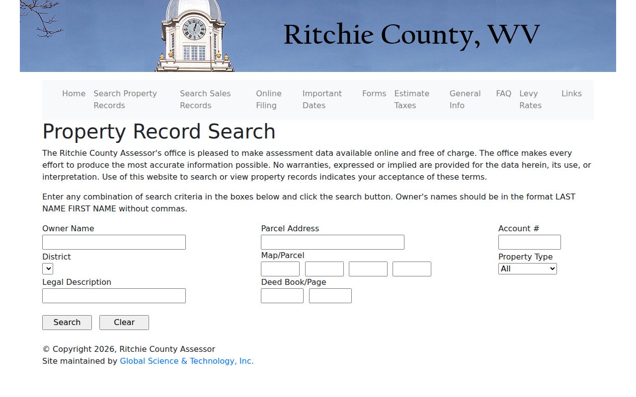
Use the screenshot as a field guide only, and read the live result carefully, since fields and options can change with county updates.
What a Ritchie County Property Result Shows
The assessor lookup bridges an address to an account. It also ties the account to a deed reference. A parcel card in Ritchie County may include owner of record, mailing address, situs address, account, district, map/parcel, property type, legal description, land and improvement value, total assessed value, exemptions, tax year, deed book/page, sale date or price, and a sketch. That is a wide net. Not every field appears on every record, so confirm what matters on the live card.
| Owner and address | Owner name, tax-mailing address, and physical situs can differ. |
|---|---|
| Parcel keys | Account and four-part map/parcel identify different cross-reference systems. |
| Land description | Legal text may be acreage, lot/block, road, creek, or mineral wording. |
| Value and exemption | Check the tax year and distinguish assessed fields from a sale result. |
| Deed reference | Book/page points toward an instrument in the County Clerk index. |
An owner name does not prove who lives at a site. A sale date does not equal the latest title event. A trust, an estate, or a split surface and mineral estate can each arise. Each can create more than one relevant instrument. When the online parcel card omits a field, contact the assessor. Do not guess from a different record system.
Address, Owner, or Map/Parcel in Ritchie County
Pick the key that fits the question. A street address is easiest for a known home. Though older descriptions may rely on roads, streams, acreage, or town plats. An owner search can surface several accounts under one person or entity. Map/parcel works best for comparing the assessment roll, tax map, and sheriff inquiry. But it is not a deed by itself.
| Search Key | Best Starting Point | What It Connects | Common Snag |
|---|---|---|---|
| Address | Assessor Parcel Address | Situs to parcel/account | Rural route, old name, or mailing/situs mismatch |
| Owner | Assessor or clerk index | Name to accounts or recorded instruments | Same-name owners, trustees, suffixes, married names |
| Account | Assessor and tax inquiry | Assessment to ticket | May change after a parcel correction |
| Map/Parcel | Assessor and GIS | Tax key to map location | Four input parts; formatting must be preserved |
Confirm a street result against the assessor's legal description. Match a party result to the property description in the deed. County record systems share no universal search key, so note both the account and the map/parcel whenever they are available.
Ritchie County Situs and Mailing Addresses
Situs is the physical place being assessed. A mailing address tells you where the tax notice goes. The owner may live elsewhere. The owner may use a post-office community name, or route bills through a business or fiduciary. The assessor's Parcel Address field and the sheriff's Billing Address field answer different questions. Keep both when comparing an assessor result with a ticket.
Ritchie County mixes town streets, state routes, rural routes, and unincorporated places. A Harrisville, Pennsboro, or Ellenboro postal address does not prove the parcel sits inside town limits. ZIP codes are delivery geography. The USPS notes that ZIP boundaries do not necessarily follow municipal ones. Use the assessor District field and GIS context for location. Then take annexation or permit questions to the town.
When a full address fails, strip apartment or unit text. Simplify directional terms, shorten the road name, or fall back to an owner search. For an old property, compare the deed's legal description with an 1899 town map or a recorded plat. The clerk index may use a prior town name. It may use a lot description instead of a modern street number.
From an Assessor Search to Ritchie County Deeds
An assessor result gives you a starting point, not the full story. Once you have an owner spelling or a book and page reference, take it to the Ritchie County Clerk Document Inquiry. That system is indexed by party name rather than address. Search the current owner first as grantee, limiting the instrument type to Deeds. Jot down the indexed date and the document type. Note the book and page, the party role, and any image or cross-reference flag. Then run the same person as grantor on the prior instrument. That keeps the transfer history walking backward.
Keep your attention on the instrument itself. A search result will not surface every reservation or easement. It may also miss a mineral split or correction buried in the document. The current online cutoff year is not stated. Older deed, land, plat, and road books can be requested from the County Clerk. The library and the Historical Society serve as useful historical leads. The Ritchie County deed records search lays out the record and copy path in detail.
One caution about timing. A purchase that closed recently may have a recorded deed newer than the assessor roll. Compare dates and instrument references before drawing conclusions. A stale owner field is not proof that no conveyance occurred.
Ritchie County Sales Search as a Lead
The assessor result is a starting point. Once it gives you an owner spelling or a book and page, take those details to the Ritchie County Clerk Document Inquiry. That system indexes by party name rather than address. Run the current owner as grantee first. Limit the instrument type to Deeds. Note the indexed date and the document type. Also note the book and page, the party role, and any image or cross-reference flag. Then search that owner as grantor on the prior instrument. That traces the transfer history backward.
Keep your attention on the instrument itself. A result line will not show every reservation, easement, mineral split, or correction buried in the document. So the recorded deed deserves a close read. The county does not state a cutoff year for online records. Older deed, land, plat, and road books can be requested from the County Clerk. The library and the Historical Society are good historical leads. The Ritchie County deed records search lays out the record and copy path.
A recent purchase can also mislead. The recorded deed may be newer than the assessor roll. So compare dates and instrument references before drawing conclusions. A stale owner field is never proof that no conveyance occurred.
Annual Data Refresh in Ritchie County
Treat the assessor roll and the state viewer as assessment snapshots. They are not live closing feeds. WV Property Assessment refreshes the viewer once a year with new assessment information. A routine ownership change may lag behind. A fresh parcel split can sit waiting on county revisions. State guidance asks that map revisions for transfers between July 1 and June 30 be submitted by February 1 of the following calendar year. If lines still look stale after two years, contact the local assessor.
That guidance is statewide, though, not a published Ritchie-specific lag from closing to roll. Suppose a new deed is recorded while the assessor still lists the seller. Keep both dates and treat the deed as the newest recorded conveyance. The assessor's office can explain how to submit an owner, mailing address, or map correction. The county's official links page connects you to its related record systems. A GIS image helps orient a Ritchie County property search. But it cannot legally confirm a boundary change.
Ritchie County Entity and Estate Names
The assessor roll and the state viewer are assessment datasets, not real-time closing feeds. WV Property Assessment says the viewer is refreshed annually with new assessment information. A simple ownership change may not have filtered through yet. A new parcel split may wait on county revisions. For transfers between July 1 and June 30, state guidance says map revisions should be submitted by February 1 of the next calendar year. It also tells users to contact the local assessor if lines remain stale after two years.
That schedule is statewide guidance, not a published Ritchie-specific closing-to-roll lag. When a new deed is recorded but the assessor still shows the seller, keep both dates. Treat the deed as the newest recorded conveyance. The assessor can explain how to submit an owner, mailing address, or map correction. The county's official links page connects its related record systems. A GIS image can orient the search. It cannot confirm a boundary change legally.
What a Ritchie County Search Cannot Prove
A Ritchie County property search is a way to find public record entries. It is not a title search. It is not a survey, a guaranteed owner match, or a current appraisal. An address can straddle postal or municipal labels. A parcel can carry split interests. The viewer may display tax lines that fall outside legal boundaries. Match sources carefully by account, map and parcel number. Check the legal description, party names, and document dates too. That care matters before drawing conclusions about who the owner of record is.
Verify the underlying record. The owner field identifies the name carried on the assessment roll; the deed index shows recorded instruments; and the sheriff portal shows tax tickets. When the facts conflict, ask each office for the record it holds instead of choosing a name by assumption.
A county search is a method for finding public record entries. It is not a title search. It is not a survey, a guaranteed owner match, or a current appraisal. An address can cross postal or municipal labels. A parcel can carry split interests. The viewer can even display tax lines that are not legal boundaries. Match sources by account, map and parcel, legal description, party names, and document dates.